Ordnance Survey Map – Wreningham 1818
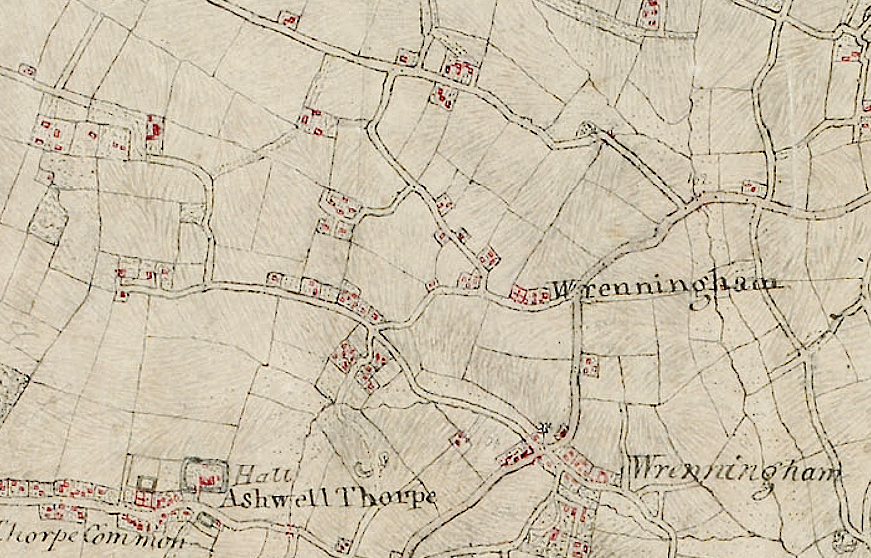
The buildings are shown in red. NB Field boundaries on this map are believed to be inaccurate
The original paper scale was 2 inches to the mile and the draughtsman was a Mr Charles Budgen
The map is provided courtesy of the British Library under an Open UK Government Licence version 1.0
Following the second Jacobite uprising (1745) in Scotland, the Ordnance Survey (OS) was set up to create new maps of Scotland to assist the army move around with greater certainty. Until then, Scotland had been poorly mapped – although the Scottish mapping survey was never totally completed due to a series of international “interruptions”. Nevertheless, a great deal about the process was learnt.
In the late 1700s, mapping was also assisted by a new generation of surveying equipment which resulted in greater accuracy than before and the OS were instructed to turn their improved skills to create comprehensive maps of England and Wales. By the mid-1800s, about 400 maps had been completed: starting along the English South Coast and reaching to an east-west line between North Wales and the Lincolnshire coast.
Our local OS map, completed in 1818 and known as the “New Buckenham map”, can be found here. The Wreningham area, illustrated above, is just a small portion of it. The collection includes 16 maps within Norfolk and they took many years to complete. This local OS map appears to be a huge improvement when making comparisons with the earlier Fadens Map of Norfolk (1797) or the slightly later Bryant’s Map of Norfolk (c1826).
Whilst residents of Wreningham were to enjoy a few advances during the 1800s, in 1818, life was still very basic. The pub had already arrived and there had been a village church for many centuries, but the village had to wait another 24 years before the construction of its first “national” school. Many might have struggled with a map – assuming they had even seen one.
Tithe Map – Wreningham c 1839
Click on quadrants below for higher quality enlargements
NB Unlike in the OS 1818 map, the field boundaries on tithe maps are very accurate – the entire point of the map!
Click on above quadrants to enlarge into new pages – with overlaps
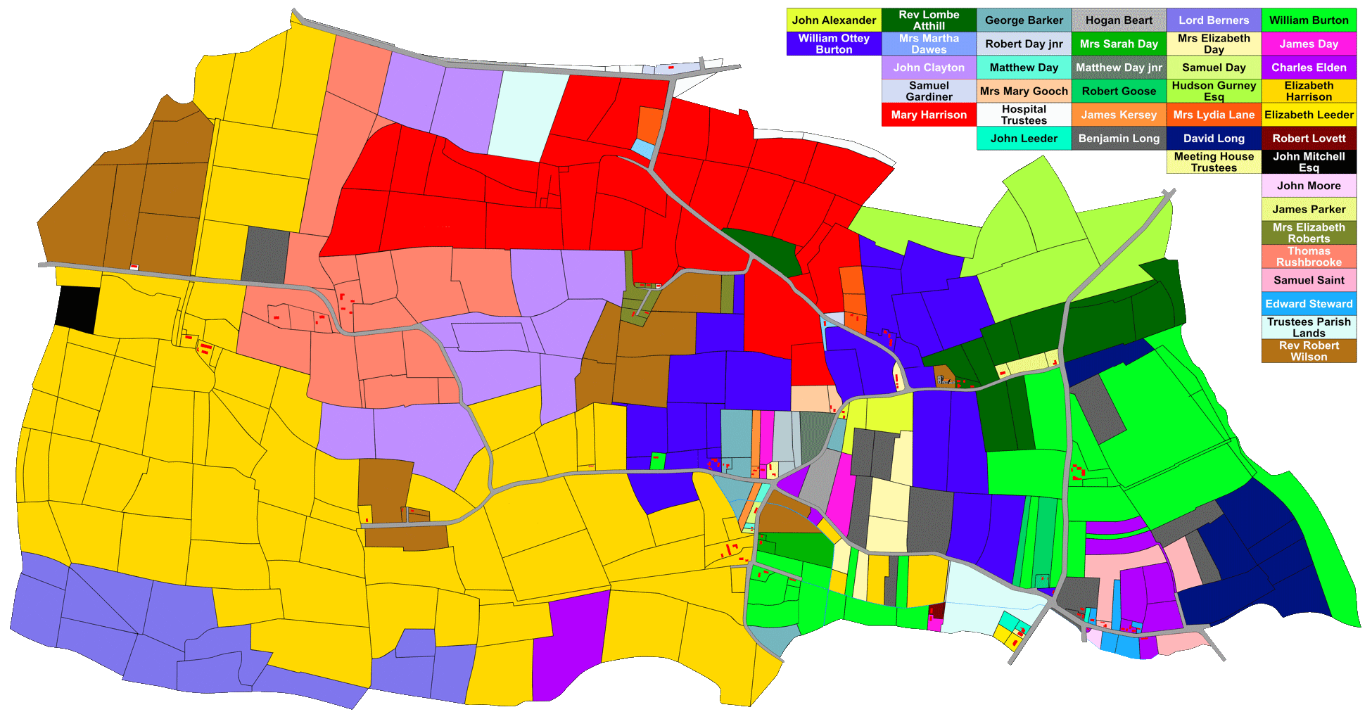
Tithes were created as a result of an act of parliament in 1836 and were part of a system devised for landowners to pay taxes to their parish church. A table of “apportionments” listed both the individual landowners and (where different) the occupiers; the apportionments table for Wreningham can be found here. The apportionment numbers were also included on the map.
Three copies were made of every tithe map. One was retained by the tithe commissioners, one went to the Diocese and third was kept by the parish. In Norfolk, the parish map copies are now in the possession of the Norfolk Record Office.
Tithe maps had their own numbering system which cross-referenced with the apportionments table and these numbers were also referenced in the tax administration process.
Farmers’ fields usually have names – often passed down through the generations. In c1838, some of these field names were incorporated within the apportionments table. Unlike in the original maps, we have included these referenced field names in our “modernised” tithe map.
In the second half of the 1800s / the early 1900s, when the Ordnance Survey produced much higher resolution maps, they created their own field numbering systems for each parish.